Post written by Alexandra St. Pe.
After a lovely start to the week with clear skies and northeast winds funneling in a cool and dry air mass, the strong high pressure system responsible for the pleasant weather conditions began to exit the Mid-Atlantic region. As the high pressure system traversed the New England states, a low pressure system developed off the Mid-Atlantic coast, locking in an all too familiar southeasterly wind flow infamous for ushering in copious amounts of moisture.
After a lovely start to the week with clear skies and northeast winds funneling in a cool and dry air mass, the strong high pressure system responsible for the pleasant weather conditions began to exit the Mid-Atlantic region. As the high pressure system traversed the New England states, a low pressure system developed off the Mid-Atlantic coast, locking in an all too familiar southeasterly wind flow infamous for ushering in copious amounts of moisture.
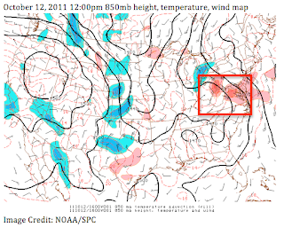
This process is known as Warm Air Advection (WAA) and is often associated with stratiform cloud decks and widespread showers. The weather map below depicts the warmer air (red shaded region) being transported inland on southeasterly winds off the Atlantic. Stratiform rain refers to light-moderate rain or rain showers that fall over a large area from layered, horizontally extensive cloud layers. (Convective rain refers to heavy showers and/or thunderstorms forming from deep, isolated clouds).
The development of this low pressure system and co-existing WAA set the stage for an overcast and wet middle of the week as the moist-laden air was forced to lift over a cooler dome of air already in place. This process is often referred to as overrunning - meaning warm, humid air will gently ascend along a sloping layer of cool air at the surface. The cool air was flowing down the east side of the Appalachians on northeasterly winds at the surface. The diagram below illustrates this process of warm (less dense) air overriding the cooler (more dense) air.
Overrunning often denotes the beginning of lengthy rain periods as showers can stream along a narrow axis as long as there is a sufficient moist airflow. The 12:00 pm analysis below from the Storm Prediction Center provides evidence of a generous tropical-like plume of moisture with dewpoint temperatures ≥ 64 degrees Fahrenheit stretching along the east coast of the US.
The upper levels of the atmosphere (~ 27,000’) were also conducive for maintaining widespread showers as divergence aloft was occurring over the shower genesis area. Divergence aloft serves as another ‘lifting’ mechanism in the atmosphere and is marked by fast moving winds spreading apart. When winds spread apart high in the atmosphere, air is drawn up from below to “fill the void”. The pocket of diverging air over the Mid-Atlantic is outlined by the purple lines below.
NWS Radar Base Reflectivity imagery indicated widespread showers across the Mid-Atlantic by 12:15pm. The light to moderate showers continued throughout the evening until the surface low pressure system finally began to retreat northeast.
Due to the blanket of clouds and showers that persisted Wednesday, temperatures didn’t budge at BWI airport- holding steady at 63 degrees Fahrenheit during the entire day! Note also the light and steady rain that fell during the event. Accumulations in the immediate DC-Baltimore metro region were few tenths of an inch, but over an inch fell in Central Virginia.


New cure for hepatitis B, herpes simplex virus (HSV), HIV and human papillomavirus (HPV). herpes zoster, shingles,,His result is 100% guaranteed..Email__________________________________ R o b i n son bu ckler11 ( @ ) gmail. com,..
ReplyDelete