 |
| NWS |
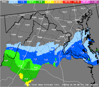
Late this afternoon, about 24 hours later, and with the storm in progress - here is a major downgrade:
 |
| NWS |
Here's the storm tonight, which has become quite vigorous, dropping heavy snow across central Virginia:
 |
| Surface Map, Thursday Evening (Intellicast) |
Why did it not snow here? As explained in my earlier blog, a layer of extremely dry air slipped into the atmosphere's snow-forming layer this morning. Even a solid deck of overcast cloud struggled to form. And the really cold air did not arrive from the north. You'll note a cold front in the surface map, above - still located north of the Mason Dixon line this evening.
Where did the air cold enough for snow come from, to our south, over South-Central Virginia? (1) Much of the heavy snow that fell this afternoon, and continues to fall this evening, is occurring at high elevation - above several thousand feet in the Blue Ridge Mountains and Appalachians - where the air layer is naturally colder. (2) Some of the chill was generated by vigorous cooling, as heavy precipitation fell through the same dry air mass that invaded our location early this morning. (3) Rain has only turned to snow across VA this evening, as the sun set and the surface air cooled to near-freezing. (4) Finally, vigorous upward motion - due to an energetic jet stream - created an effect called "dynamic cooling" (air cools as it is forced to rise and expand).
The really intense jet stream in fact is powering a band of heavy snow, with rates of 1"-2" per hour, and even thundersnow, across central VA. The snow is heavy and wet and will undoubtedly cause widespread power outages. The radar image below shows this rather isolated but heavy pocket of snow (blue shades):
 |
| Heavy snow over Central VA this evening. WeatherTap |
The snow band has set up in the classic location, within 200 miles to the northwest of the low's center. I'm thankful that this heavy snowstorm was a miss...and it's unusual to see such an event to the south of D.C. - Baltimore!
No comments:
Post a Comment