The NWS released a public information statement. They are in the process of compiling and analyzing rain gauge reports in the Washington-Baltimore region from Hurricane Irene and Ex-Tropical Storm Lee. There are a few stations (including Largo, MD and Forestville, MD) that recorded a total of ***24 INCHES*** of rainfall from these two storms. To put this in perspective, our region averages about 35"-40" of rain in any given year. Imagine receiving 2/3 of this in the space of a single week!
Additionally, stations in Northern Virginia accumulated rainfall at such an extreme rate that these locations have effectively just experienced a 500- to 1000- year storm event.
The hydrologic (land surface) response to these events was quite varied across the Mid Atlantic. These aspects are being studied by Professor Andrew Miller and colleagues in UMBC's Geography Department.
Thursday, September 15, 2011

September 15: Tornado Just Off Ocean City
The photo below shows a tornado in the vicinity of Ocean City, MD taken this afternoon. The tornado was produced by a thunderstorm cell that formed in unstable air, ahead of a strong cold front pushing across Maryland. The large, funnel-shaped appearance of the tornado cloud and broad spray ring suggests that this developed as a tornado over land and subsequently moved offshore, as opposed to a waterspout that initiated over the ocean - but the NWS is trying to substantiate this. Tornadoes - even those that move over water - tend to contain higher wind speeds than waterspouts. Tornadoes and waterspouts also form by different mechanisms.
 My own examination of the radar imagery this afternoon (shown below) identifies the cluster of thunderstorm cells that I believe may have generated the tornado (located inside the thick red circle). The cold front advancing across Maryland (thick, solid blue line) is also shown.


Friday, September 9, 2011
September 9, 2011: Tropical Rain Catastrophes In The Washington-Baltimore Corridor: A Repeating Pattern?
I've gone into the meteorological archives and extracted the truly catastrophic tropical rain events in the last 50 years over the Washington-Baltimore region. There are four significant storms, each producing 10"-15" across our greater urban area during a multi-day period. They are:
1. Hurricane Agnes, June 1972 (max 19", Schuylkill County, Central PA)
2. Hurricane Eloise, September 1975 (max 14", Westminster, Central MD)
3. Unnamed Tropical Plume, June 2006 (max 17", Tamaqua, Central PA)
4. Tropical Storm Lee, September, 2011 (preliminary max 15"+, NOVA)
The rain accumulation maps for these four events are posted below. Note that the first three are based on Dave Roth's (NOAA) analysis of thousands of rain gauges. It will take some time for his group to do a similar, definitive analysis for Tropical Storm Lee; for now, we are using radar estimates, which can be off by a factor of two compared to gauges (click on these to enlarge):

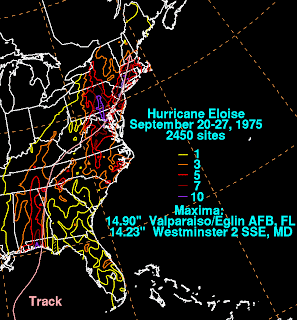


There are four major tropical rain storms in 50 years, each producing different degrees and types of hydrological response, but there are remarkable similarities in the heavy rain distribution. Considering just the Mid Atlantic, all four events feature a narrow swath of 10"-15" oriented north-south and extending from north-central VA through central MD then into central PA...and including the major cities of Washington and Baltimore. This heavy rain swath seems to set up regardless of the track of the tropical cyclone (if there was one), or its intensity at landfall. The big question: Is all of this just coincidence, or do these analyses suggest that there is a recurring, perhaps predictable set of processes - a "preferred mode" - that defines rain axis intensity, orientation and persistence in our part of the world?
Clearly, there is some work that needs to be done here, to better understand the dynamics and physiographic interactions. What I can say, after a preliminary look at all the meteorological charts, is this:
1. Each case featured a deep plume of tropical moisture circulating into the core remnants of the storm, or just a narrow tropical plume. The plume contains southerly winds that import high humidity air over the region;
2. Each case featured a north-south oriented stationary front draped through the region...along which the tropical moisture spread northward. When moist, southerly airflow was constrained to flow along this front, a pattern of repeat echo training was established;
3. North of the Mason-Dixon line, the corridor of tropical airflow impinged upon the Appalachians, which are oriented west-east across South-Central PA. This helped propagate heavy rain cells in a narrow corridor northward through PA.
There are many other aspects that come into play...including the overall progression (speed) of the parent tropical circulation, its intensity as it moved inland, its interaction with dynamical processes in the upper troposphere such as jet stream troughs and jet streaks, etc. But perhaps there is a core set of processes and configurations common to all of these high impact events...making this densely populated region particularly vulnerable to repeated, catastrophic rain events of a tropical nature.
In terms of the large-scale ingredients that lead to the Lee rainfall disaster, the following diagram attempts to portray some of them. Lee's large circulation moved very slowly up the spine of the Appalachians. A persistent conduit of tropical moisture was pulled northward over the Mid Atlantic on Lee's east side. A stationary front (which at times became incorporated into Lee's remnant circulation as a warm front during the system's extratropical transition) remained over Washington-Baltimore for several days. The front, oriented parallel to and embedded within the moisture plume, served as a persistent focus for heavy rain by lifting moist, tropical air. Finally, note that Lee's circulation did something quite rare - it headed westward on Sept 8-9. Such motion is termed retrograde movement.

1. Hurricane Agnes, June 1972 (max 19", Schuylkill County, Central PA)
2. Hurricane Eloise, September 1975 (max 14", Westminster, Central MD)
3. Unnamed Tropical Plume, June 2006 (max 17", Tamaqua, Central PA)
4. Tropical Storm Lee, September, 2011 (preliminary max 15"+, NOVA)
The rain accumulation maps for these four events are posted below. Note that the first three are based on Dave Roth's (NOAA) analysis of thousands of rain gauges. It will take some time for his group to do a similar, definitive analysis for Tropical Storm Lee; for now, we are using radar estimates, which can be off by a factor of two compared to gauges (click on these to enlarge):


There are four major tropical rain storms in 50 years, each producing different degrees and types of hydrological response, but there are remarkable similarities in the heavy rain distribution. Considering just the Mid Atlantic, all four events feature a narrow swath of 10"-15" oriented north-south and extending from north-central VA through central MD then into central PA...and including the major cities of Washington and Baltimore. This heavy rain swath seems to set up regardless of the track of the tropical cyclone (if there was one), or its intensity at landfall. The big question: Is all of this just coincidence, or do these analyses suggest that there is a recurring, perhaps predictable set of processes - a "preferred mode" - that defines rain axis intensity, orientation and persistence in our part of the world?
Clearly, there is some work that needs to be done here, to better understand the dynamics and physiographic interactions. What I can say, after a preliminary look at all the meteorological charts, is this:
1. Each case featured a deep plume of tropical moisture circulating into the core remnants of the storm, or just a narrow tropical plume. The plume contains southerly winds that import high humidity air over the region;
2. Each case featured a north-south oriented stationary front draped through the region...along which the tropical moisture spread northward. When moist, southerly airflow was constrained to flow along this front, a pattern of repeat echo training was established;
3. North of the Mason-Dixon line, the corridor of tropical airflow impinged upon the Appalachians, which are oriented west-east across South-Central PA. This helped propagate heavy rain cells in a narrow corridor northward through PA.
There are many other aspects that come into play...including the overall progression (speed) of the parent tropical circulation, its intensity as it moved inland, its interaction with dynamical processes in the upper troposphere such as jet stream troughs and jet streaks, etc. But perhaps there is a core set of processes and configurations common to all of these high impact events...making this densely populated region particularly vulnerable to repeated, catastrophic rain events of a tropical nature.
In terms of the large-scale ingredients that lead to the Lee rainfall disaster, the following diagram attempts to portray some of them. Lee's large circulation moved very slowly up the spine of the Appalachians. A persistent conduit of tropical moisture was pulled northward over the Mid Atlantic on Lee's east side. A stationary front (which at times became incorporated into Lee's remnant circulation as a warm front during the system's extratropical transition) remained over Washington-Baltimore for several days. The front, oriented parallel to and embedded within the moisture plume, served as a persistent focus for heavy rain by lifting moist, tropical air. Finally, note that Lee's circulation did something quite rare - it headed westward on Sept 8-9. Such motion is termed retrograde movement.

Wednesday, September 7, 2011
September 7, 2011: Serious Hydrological Event Underway
The remnants of ex-Lee continue to impact the Baltimore region. The large-scale storm circulation has become nearly stationary, and is located over the Great Smoky Mountains...where it was yesterday. On its eastern side, a warm front remains draped across the Washington-Baltimore region. A tropical plume of high humidity is being lifted along this front.
The movie below shows a phenomenon called echo training...whereby storm cells form within the tropical moisture plume, and move repeatedly over the same locations. The cells are developing south of Baltimore, and moving northward across the city, one after another. Each cell dumps a load of rain. Then the next one arrives. The "train" sets up whenever the winds aloft blow parallel to a stalled front. In this case, very humid flow from the south is running parallel to the warm front, which is also oriented south to north. The result is a very wet conveyor belt:
Shown below are the flash flood warnings that have been posted for our region...note how they all run along the axis of the echo train:

 | |
| Surface map, 8 AM, showing ex-Lee's circulation situated over Appalachia. A warm front extends northward across Washington-Baltimore. |
 |
| Plume of high tropical moisture streaming from south to north over the Washington-Baltimore region. |
Shown below are the flash flood warnings that have been posted for our region...note how they all run along the axis of the echo train:

Tuesday, September 6, 2011
September 6, 2011: Lee's Tropical Plume Soaks The Mid Atlantic
On Sunday, September 4, the broad circulation of Tropical Storm Lee came onshore along Louisiana. The wind field around the storm's core rapidly weakened, but heavy rain has become problematic across the entire U.S. east of the Mississippi. Ex-Lee's post-tropical circulation continues to import vast amounts of moisture northward out of the Gulf of Mexico. This plume of tropical air, called an "atmospheric river", shows up in the satellite water vapor imagery, and is analyzed in terms of "precipitable water" (shown below). Precipitable water is a simple measure of the total water vapor content of the air. Professor Ray Hoff in Physics pointed out an atmospheric river impacting the West Coast, but we get them here in the East as well:
This plume of tropical moisture (dark green shades, up to 2.5" precipitable water) has its origins in the western Gulf of Mexico. The plume is overriding a stationary front anchored along the spine of the Appalachians, stretching from Florida to Maine. Lee's remnant circulation has become embedded in this front, and is moving slowly toward the northeast along the frontal boundary. The sequence of two figures below shows how Lee interacted with this front (the first weather map shows conditions at 8 AM Monday, the second shows 8 AM today). When a post-tropical weather system combines with a front in this manner, and a wave-type frontal cyclone structure develops, the evolutionary process is called extratropical transition (ET). As ET unfolds, all types of severe and hazardous weather can ensue...sometimes hundreds of miles inland from the coastline.
Another facet of inland, post-tropical evolution is tornado formation. In the 8 AM Tuesday weather map above, note the red tornado watch boxes issued for the Carolinas. The favored location for tornado formation in decaying tropical remnants is the right front quadrant of the storm. This is where the low level wind shear, and potential for air to develop rotation, is greatest.
Here is a more detailed, regional (mesoscale) surface analysis of ex-Lee. Early this afternoon, the storm center was located over the Smoky Mountains. The pressure gradient is fairly weak, so widespread strong winds are not a concern. Note several spiral rain bands sweeping over the Carolinas and southeastern Virginia. Also note how the isobars (solid black lines) dip southward across Virginia. This pattern is suggestive of Appalachian cold air damming. In cold air damming, low-level winds get channeled from the northeast, from the cool North Atlantic, down the Virginia Piedmont. This cool dome of surface air, trapped up against the Appalachians, is one reason why temperatures are struggling to climb out of the mid-60's today.
In case you are wondering how much rain will fall, and where, the Hydrometeorological Prediction Center (HPC) offers this forecast for 5-day rain accumulation:
The heaviest pocket of rain, 10"+, is expected to fall west of the Allegheny Front. This is significantly west of where Irene produced heavy rain, which amounted to 8"-10" along the coastal plain. It seems that the combination of orographic rain enhancement (lifting of tropical air along the Appalachians) and the tendency for heavy rains to fall left of track in post-tropical, inland storms...are two explanations in support of HPC's prediction.
 |
| Deep, continuous river of tropical moisture extending from the Gulf of Mexico over the Mid Atlantic. |
 |
| Surface weather map, 8 AM Monday, showing Tropical Storm Lee making landfall. Note the extensive slow-moving cold front along the Appalchians. |
 |
| Surface weather map, 8 AM Tuesday. Lee's circulation is now embedded within the cold front, and is evolving into a classic mid-latitude wave cyclone. The entire system is lifting slowly toward the northeast. |
Here is a more detailed, regional (mesoscale) surface analysis of ex-Lee. Early this afternoon, the storm center was located over the Smoky Mountains. The pressure gradient is fairly weak, so widespread strong winds are not a concern. Note several spiral rain bands sweeping over the Carolinas and southeastern Virginia. Also note how the isobars (solid black lines) dip southward across Virginia. This pattern is suggestive of Appalachian cold air damming. In cold air damming, low-level winds get channeled from the northeast, from the cool North Atlantic, down the Virginia Piedmont. This cool dome of surface air, trapped up against the Appalachians, is one reason why temperatures are struggling to climb out of the mid-60's today.
 |
| Detailed analysis of ex-Lee centered over Ashville, N.C. Note the spiral rain bands on the storm's eastern side, some of which may be producing tornadoes. |
 |
| HPC prediction of 5-day total rain accumulation. |
Monday, September 5, 2011
September 5, 2011: Katia and Lee

As of this morning, Katia is expected to recurve away from the U.S. East Coat and accelerate toward the northeast, later in the week. The post-tropical remnants of Lee are predicted to move slowly northward along the Eastern Seaboard through the week. The remnants will approach the Mid Atlantic, advancing along a stalled cold front. The combination of this front, plume of tropical moisture, ascent of moist air along the Appalachians, and slow movement of ex-Lee promises excessively heavy rainfall across the Southeast, and potentially over portions of the Mid Atlantic.
Here is the morning surface map, showing the front, with ex-Lee embedded in the front over the Gulf Coast:


Wednesday, August 31, 2011
Further Analysis of Irene's Impacts On The Mid-Atlantic
Here are a couple of interesting analyses post-mortem on Irene. The first was sent to me by UMBC Ph.D. student Aaron Poyer, who is in my research group studying severe storms. This is the 7-day rain accumulation that brackets the storm's trek up the Eastern Seaboard. The swath of red and purple tells the story - with 15"-20" across eastern North Carolina. Keep in mind that these are early radar estimates and these maps will be refined over time. I will post analyses that use rain gauge data as they become available. Click on this image to see more detail.

Here is a more regionally-focused rain map released by NWS Washington-Baltimore:

For comparison, here is the rain accumulation map for Floyd (1999), for which readers of this blog know I have made a rainfall analogy:
 However, while the track and rain are very similar, it is important to bear in mind that Floyd hit as a Cat 2, and evolved in a different manner than Irene. Floyd underwent a classic extratropical transition across the Mid Atlantic, while Irene's was delayed until reaching New England. But I find it very interesting that the rain patterns and intensities came out quite similar.
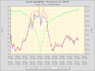
This next figure was sent to my by Ray Hoff, UMBC Physics Professor, who received it from a colleague of his at Johns Hopkins. The graph shows a dramatic time series of pressure and wind, based on 1-minute surface observations, collected at NOAA's Chesapeake Bay Lighthouse. The lighthouse had a very close encounter with Irene's center. The data have not been quality controlled, but the impacts are quite apparent.
The pressure trace is classic hurricane, featuring an exponential decrease and rise. The storm's central region shows a sharp drop in wind speed at the time of minimum surface pressure. Peak eyewall winds are symmetric before and after center passage...keep in mind that 60 kts equates to about 70 mph. The fall off in wind (second wind) as the storm retreated unfolded much faster than the wind rise (first wind) as the storm approached. This is interesting because the pressure trace rise and fall is perfectly symmetric.
Since this is a water station, we wouldn't expect to observe a large gust factor (increase in gust speed over 1-min sustained winds). For the Irene trace, this is generally the case, except during eyewall passage, when gust factor became more significant. As the sustained winds increased, so did the turbulence. I wonder if the lighthouse structure itself generated the observed turbulence? This suggests just how hard it is to get clean measurements of a meteorological phenomenon.
Here is a final figure, provided by NWS Washington/Baltimore, that maps the most extreme wind gusts across our region. There is a gradient in winds, from NW to SE, with the strongest gusts (65-70 mph) over Calvert and St. Marys Counties, which were closer to the track of the storm than Baltimore County. The pocket of higher winds through Montgomery, Frederick and Carroll Counties (50-55 mph) is interesting; I would not have anticipated this ahead of time, given the more inland location of this region.


Here is a more regionally-focused rain map released by NWS Washington-Baltimore:

For comparison, here is the rain accumulation map for Floyd (1999), for which readers of this blog know I have made a rainfall analogy:

This next figure was sent to my by Ray Hoff, UMBC Physics Professor, who received it from a colleague of his at Johns Hopkins. The graph shows a dramatic time series of pressure and wind, based on 1-minute surface observations, collected at NOAA's Chesapeake Bay Lighthouse. The lighthouse had a very close encounter with Irene's center. The data have not been quality controlled, but the impacts are quite apparent.
The pressure trace is classic hurricane, featuring an exponential decrease and rise. The storm's central region shows a sharp drop in wind speed at the time of minimum surface pressure. Peak eyewall winds are symmetric before and after center passage...keep in mind that 60 kts equates to about 70 mph. The fall off in wind (second wind) as the storm retreated unfolded much faster than the wind rise (first wind) as the storm approached. This is interesting because the pressure trace rise and fall is perfectly symmetric.
Since this is a water station, we wouldn't expect to observe a large gust factor (increase in gust speed over 1-min sustained winds). For the Irene trace, this is generally the case, except during eyewall passage, when gust factor became more significant. As the sustained winds increased, so did the turbulence. I wonder if the lighthouse structure itself generated the observed turbulence? This suggests just how hard it is to get clean measurements of a meteorological phenomenon.

Here is a final figure, provided by NWS Washington/Baltimore, that maps the most extreme wind gusts across our region. There is a gradient in winds, from NW to SE, with the strongest gusts (65-70 mph) over Calvert and St. Marys Counties, which were closer to the track of the storm than Baltimore County. The pocket of higher winds through Montgomery, Frederick and Carroll Counties (50-55 mph) is interesting; I would not have anticipated this ahead of time, given the more inland location of this region.

Subscribe to:
Posts (Atom)