Wednesday, March 20, 2013

March 20, 2013: A Storm Looking More Certain Sunday Night

A consensus is emerging that a complex coastal storm will develop off the Eastern Seaboard this Sunday into Monday.

However, most computer models suggest that there will be two pieces of energy - a primary system over the Tennessee Valley, and a secondary or coastal piece of energy off Cape Hatteras. 

There are significant differences in the models on which storm will predominate, and in particular their tracks and intensities. 

For now, a wintry mix is on the table for the D.C. - Baltimore metro region, with elevation-dependent snow (possibly heavy) over the mountains to our north and west. 

Once the storm departs Monday morning, a reinforcing blast of chilly arctic air returns to start the first week of April.

Here is the best guess concerning positions and intensities of the two storms, from the NOAA Weather Prediction Center:

Forecast Map, Sunday Morning
In this map, note the two areas of low pressure (Tennessee Valley and Georgia).   A weak wedge of cold air damming remains in place between the two systems, over the Mid Atlantic (blue "H" over NY-PA).

Forecast Map, Monday Morning
Note how the two systems remain separate. Eventually the primary storm over the Tennessee Valley weakens, drifting northeast, while the secondary of coastal system deepens as it moves northeastward away from Cape Hatteras.  Neither storm is very intense.  This is a bit of an "outside track" for a coastal low to clobber us with heavy snow.  However, with the western piece of energy and enough cold air in place, we could still pick up accumulating snow in some parts of the region.

Bottom line:  I expect a rain-sleet-snow mix here overnight Sunday, with a low chance of a major snowstorm. 

Stay tuned as the details of this complex forecast continue to get better resolved.

Tuesday, March 19, 2013

March 19: Next Potential Storm Still Highly Uncertain


In year’s past, I have blogged about the lessons learned from the 1942 Palm Sunday (March 29) snowstorm, which buried Baltimore in 22 inches of heavy, wet snow.    It was outright crippling in terms of downed trees, broken utilities and clogged transportation arteries.    There was a real “shock and awe” factor with this one – as the following pictures attest:
Library of Congress

Library of Congress
So, even though this is an extreme “outlier” event, there is precedent;  it could happen again.    Today, the computer models continue to advertise a significant coastal low or Nor’easter in the March 25-26 timeframe.    This, thanks to an unusually cold late-March air mass coming down from Canada.    When air this cold moves along the warm Atlantic’s Gulf Stream the Polar Front becomes prime breeding ground for a coastal storm.
With the possible storm still about a week out, there continues to be a lot of uncertainty in the model projections…in terms of storm location, intensity, track and manner in which it taps the cold air.    Odds are against a major snow storm during early spring, due to high Sun angle and warmer air masses to our south and east.  Also, the western Atlantic water is very warm, and if this air invades the D.C. – Baltimore region (in the lowest few thousand feet), it means a rainy day, not snow. 
At this point, I give equal probability to all of the following options:  All rain, mix of rain and snow, a big snow, nothing at all – which means I have about zero confidence in what may happen seven days from now.
Stay tuned, and as usual, this next “event” will probably have everyone on edge as the weekend draws near.

Sunday, March 17, 2013

17 March, 2013: Slippery Monday AM Commute Likely

Winter has returned.  First, let's detail the moderate impact, wintry event on tap for tomorrow morning.  I label this storm "moderate" because even though total frozen precipitation is expected to remain light (1" or so across the Metro region), the timing is rotten, with various forms of frozen precipitation (snow, sleet) falling through the Monday AM rush.

The NWS has issued a Winter Weather Advisory for the western D.C. and Baltimore suburbs, effective tonight through tomorrow late morning, for slippery travel:


The Metro regions are barely on the edge of this advisory.   In Central Maryland, the region of more significant impact is actually upper Montgomery and Howard Counties, where elevations are higher.

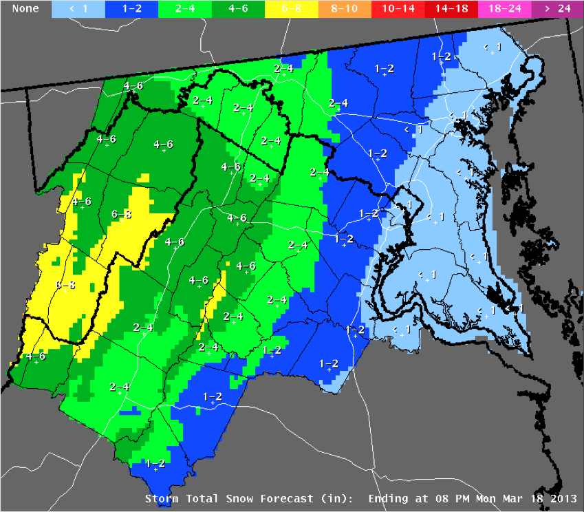
Here is the NWS accumulation map:


Like the last winter storm, this one is expected to be strongly elevation-dependent, with heaviest snow tied to colder air at the mountain tops.   The Metro region is far from the expected snow accumulation bulls eye.

What's causing this wintery scenario over the Metro region?  A weak area of low pressure approaching from the Tennessee Valley will pull in Atlantic moisture and create uplift of air.  A classic pattern of Appalachian Cold Air Damming will supply marginally cold air over the low elevations.  The damming is a subfreezing layer of air just a few thousand feet thick, wedged up against the eastern slopes of the Appalachians.   The cold air is being pumped southward by high pressure over eastern Canada.  The forecast map below shows the interaction of these elements:

The blue H = high pressure over Canada, while the red L = low pressure over Kentucky.  Shaded colors indicate intensity of precipitation.

We will have an air layer cold enough for snow and/or sleet over the Metro region, with Atlantic moisture overrunning the cold dome.   As the high pressure moves eastward through the day on Monday, the wind direction will shift from a northerly to an easterly flow, bringing in warmer air off the mild Atlantic.  This changes frozen precipitation to rain sometime Monday morning.  Plain rain will persist through Monday night.

What could go wrong with this forecast?   (1)  The warmup will be delayed, leading to a longer period of frozen precipitation through the day Monday.   Whenever we deal with cold air damming scenarios, this is always a possibility.  The cold, dense air is hard to "scour out" and the prediction models often make the transition to warmer air too quickly.  (2) The primary low to our west will transfer its energy to a coastal low, which then tracks up the New England coastline (dumping heavy snow on interior New England).  The details of how the transfer will play out can impact available moisture, timing and intensity of uplift, and the wind field - all of which confound the forecast of multiple wintry precipitation types across our region.

How about the potential for a major snow storm late next weekend?   Several cards are still on the table, including (1) a source of deep, subfreezing air moving southeast out of Canada;  and (2) formation of a coastal storm, somewhere along or off the Atlantic coast.   The details of the storm's formation 7+ days out remain problematic.  Last night's model runs (both the GFS and ECMWF) developed a major, slow-moving cyclone off Cape Hatteras, with a frigid air mass in place over Washington-Baltimore - meaning big time snow.   However, the afternoon runs of these same models have shifted the region of cyclone formation further south and east, over open ocean, and create the storm later, starting Tuesday, March 26.  If these latest model runs are true, the impact here is minimal, or none at all.

The two sets of graphics below illustrate the large difference between the earlier and later model runs (the ECMWF is shown, but the GFS had very similar trends):

Earlier ECMWF run:  Major Baltimore Snow Storm (Weatherbell Analytics)
Later ECMWF run:  A Miss for Baltimore (Weatherbell Analytics)
The bottom line:  The models want to create a powerful Nor'easter off the southeast U.S. coast early the week of March 25, feeding off an unseasonably cold air mass spreading east out of Canada.   A lot also depends on what is happening at jet stream level, which I am not showing here.  I expect that the models will waffle back and forth on various scenarios as we head into the coming week.  Our confidence will grow once a stable trend emerges.  This is one to keep a close eye on. 

March 17, 2013: Crushing Blizzard Possible Next Weekend

Folks, winter is a long way from ending around here.   Absolutely bone-chilling air is moving down into the central and eastern U.S. this coming week.   Now, several of the forecast models (GFS, European) are predicting a major east coast Nor'easter with heavy snow and high wind over the Carolinas and Mid Atlantic late next weekend.   The development of this type of intense, late March system is not unprecedented and is wholly consistent with an arctic air mass moving toward the East Coast.   This could be a crippling, 1+ foot snowstorm for D.C.-Baltimore. 

I just want to toss the idea out there now, and I will have much more to say about this storm, as we follow the forecast every day this coming week. 

In the meantime, we are still on track for a 1" or so slushy snow-sleet-rain mix tonight and tomorrow morning.  I'll have more to say on this storm around 4 pm today...so stay tuned.

Friday, March 15, 2013

March 15, 2013: Spring Ain't Here - More Snow Coming?

Well, it sure feels mild out there in the strong mid-March Sun, but the large-scale weather patterns have another idea in mind, to close out this month.

One of the big indicators of short-term (7-10 day) climate variation, called the North Atlantic Oscillation (NAO) Index, has swung highly negative - in fact the most negative it's been all winter long.  A negative phase of the NAO means a jet stream pattern that favors persistent, abnormally cold air over the Eastern U.S. 

You can see it here:

Courtesy NOAA
The red curves at the very end of the top panel indicate that the NAO index is forecast to remain very negative through the rest of March. 

Unseasonably cold air masses will visit our region over the next week.  Tomorrow through Monday, two weak waves will move through, each producing light precipitation - mainly rain.  However, the disturbance Sunday night has the potential to work with some really chilly air, stuck against the east slopes of the Appalachians.   This is called Cold Air Damming.  The sub-freezing air layer may spell a period of light, wintry mix Sunday night into Monday morning:  Cold rain, sleet, snow.  The NWS thinks that any accumulation (again, light) will occur along the Mason Dixon Line and in the higher western elevations.   But we're in for a 2-3 day ride of chilly, gray, damp, miserable weather - much more of a mid-January type of weather pattern.

One of the medium-range forecast models, the GFS, is hinting at a more significant winter storm for our region next Saturday-Sunday, as we get into the backside of a coastal low with an air mass cold enough for all snow.  Well, we'll see.  Such a storm is consistent with the strongly negative NAO.   But climatologically, a big snow event is not very likely after the vernal equinox (which occurs late this coming week).  And I am very reticent to make any type of forecast call based on one run of a single model 9 days in the future.   It's worth noting, for the record, but so very much can change in the models over the next 8-9 days.  I would not bet money on this scenario. 


Wednesday, March 6, 2013

March 6, 2013 3 PM Snowstorm Winding Down

This is the storm that The Weather Channel (TWC) has named Winter Storm Saturn.   Otherwise known around here as the Sequesterstorm, or The Big Slop.

The coastal low, while intensifying this afternoon, is out to sea and is exiting our region.  It was a very compact system with a heavy but relatively small precipitation shield - with the bulls eye of liquid water content centered right over us.  Truly a Mid Atlantic-Only storm.

As of 3 pm, the precipitation shield is finally on the move, ejecting toward the ocean.   The mesoscale prediction models predict that the back edge of solid precip will clear D.C.-Baltimore by 6 pm this evening.

Here are some images of the storm, from different vantage points, at 3 PM.  The first is the weather radar, which indicates that most of the precipitation has turned to light rain across the region:

Weaathertap
The bright yellow-red region over the Eastern Shore is an artifact of the radar at Wilmington, DE called a "bright band" and it does NOT indicate a cluster of thunderstorms.

Next up is the false-color infrared image, which gives information about cloud top temperature and height.   The storm does not look nearly as well-organized in this presentation, but the swirl of low-level cloud about the storm's center of circulation is evident:

Weathertap
Here's the view of the storm from the water vapor channel.  The circulation is pulling in extremely dry air on its south side (orange shades), from as far away as Florida!

Weathertap
Here is the final snow total accumulation prediction from NWS Sterling.  Verification of these values is going to be difficult. The wet nature of the snow makes it very hard to measure, because of compacting, partial melting, flowing and ponding on surfaces.  


The general gradient in snow from east to west was well-predicted for this storm.  The nature of the snow - heavy and wet - was also a good prediction.  Here are some surprises or "curve balls" this storm threw into what proved to be a very challenging forecast:

1)  Timing.  The storm got ahead of the forecast by about 6 hours.   Pure snow started falling area-wide by midnight, whereas most forecasts held off the arrival of all snow until daylight or mid- morning.  Likewise, as the bulk of the precip will depart the region by 6 PM, this is sooner than called for yesterday;

2)  Type of Precipitation.  In many locations, light snow and rain were mixed together through much of the day.   This cut down the snow accumulation predictions compared to last night, especially for the D.C. - Baltimore corridor;

3)   Melting Through The Day.   Temperatures remained several degrees above freezing, and even rose slightly during the day at some locations.   Early, wet snow that started to stick on trees melted through the day.  That, and the gusty winds, allowed the trees to shed their burden, sparing us from widespread power outages.   Anticipation of power outages was perhaps the most dreaded aspect of this storm;

4)   Stronger Wind Gusts Than Forecast:   Last night, peak gusts were predicted to approach 35 mph, when in fact several locations were reporting gusts to nearly 50 mph early this afternoon - the province of Wind Advisory Criteria.

5)  The Enormity of the Snow Accumulation Gradient:   This is about as extreme as I've seen in the Mid Atlantic.  2" along I-95, vs. 20" along I-81 - a factor of ten difference.  By all aspects, what defined the heavy snow region was altitude dependance.    Here is a preliminary set of observed totals:


This will be the final post on this storm event.


March 6, 2013 Heart Of Storm Has Arrived

The snow storm is in full swing across the region, and will continue through the day.

The coastal low has formed over night and is off Norfolk, VA this morning.  A compact band of precipitation is wrapping around the north and west sides of the storm, setting up shop from southern PA to WV to northern NC.


Bands of moderately intense snow are moving from east to west across our region.  Warm air is invading from the ocean, pushing the rain-snow line very close to the DC-Baltimore region:


Heavy, wet snow is falling over the cities, in proximity to this melting line.

Winds have also picked up, presently from the NE, gusting to near 30 mph, as air streams into the low pressure to our south.

There is concern that a heavy snow band will set up, somewhere W and N of the storm, as the storm continues to intensify.  This would lead to 1"-2"+/hr snow accumulation over a localized area.

Timeframe:  The storm will slowly move toward the E-NE through the day.  By noon, we should see the wind back around to the N, bringing in colder air - ensuring continued production of snow.   Snow
continues through the afternoon.  By late afternoon, the back edge of the storm and colder air may produce a drier, more granular type of snow.   Most of the snow exits the cities around 6-7 pm this evening.  Winds will continue gusting to 30-35 mph at times, particularly as bands of snow move through.

The latest accumulation totals from NWS Sterling:


Bottom Line:  Baltimore straddles the 6" accumulation line, while 6"-8" will fall over the DC region.