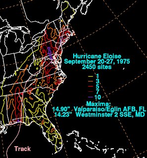
I've gone into the meteorological archives and extracted the truly catastrophic tropical rain events in the last 50 years over the Washington-Baltimore region. There are four significant storms, each producing 10"-15" across our greater urban area during a multi-day period. They are:
1. Hurricane Agnes, June 1972 (max 19", Schuylkill County, Central PA)
2. Hurricane Eloise, September 1975 (max 14", Westminster, Central MD)
3. Unnamed Tropical Plume, June 2006 (max 17", Tamaqua, Central PA)
4. Tropical Storm Lee, September, 2011 (preliminary max 15"+, NOVA)
The rain accumulation maps for these four events are posted below. Note that the first three are based on Dave Roth's (NOAA) analysis of thousands of rain gauges. It will take some time for his group to do a similar, definitive analysis for Tropical Storm Lee; for now, we are using radar estimates, which can be off by a factor of two compared to gauges (click on these to enlarge):
There are four major tropical rain storms in 50 years, each producing different degrees and types of hydrological response, but there are remarkable similarities in the heavy rain distribution. Considering just the Mid Atlantic, all four events feature a narrow swath of 10"-15" oriented north-south and extending from north-central VA through central MD then into central PA...and including the major cities of Washington and Baltimore. This heavy rain swath seems to set up regardless of the track of the tropical cyclone (if there was one), or its intensity at landfall. The big question: Is all of this just coincidence, or do these analyses suggest that there is a recurring, perhaps predictable set of processes - a "preferred mode" - that defines rain axis intensity, orientation and persistence in our part of the world?
Clearly, there is some work that needs to be done here, to better understand the dynamics and physiographic interactions. What I can say, after a preliminary look at all the meteorological charts, is this:
1. Each case featured a deep plume of tropical moisture circulating into the core remnants of the storm, or just a narrow tropical plume. The plume contains southerly winds that import high humidity air over the region;
2. Each case featured a north-south oriented stationary front draped through the region...along which the tropical moisture spread northward. When moist, southerly airflow was constrained to flow along this front, a pattern of repeat echo training was established;
3. North of the Mason-Dixon line, the corridor of tropical airflow impinged upon the Appalachians, which are oriented west-east across South-Central PA. This helped propagate heavy rain cells in a narrow corridor northward through PA.
There are many other aspects that come into play...including the overall progression (speed) of the parent tropical circulation, its intensity as it moved inland, its interaction with dynamical processes in the upper troposphere such as jet stream troughs and jet streaks, etc. But perhaps there is a core set of processes and configurations common to all of these high impact events...making this densely populated region particularly vulnerable to repeated, catastrophic rain events of a tropical nature.
In terms of the large-scale ingredients that lead to the Lee rainfall disaster, the following diagram attempts to portray some of them. Lee's large circulation moved very slowly up the spine of the Appalachians. A persistent conduit of tropical moisture was pulled northward over the Mid Atlantic on Lee's east side. A stationary front (which at times became incorporated into Lee's remnant circulation as a warm front during the system's extratropical transition) remained over Washington-Baltimore for several days. The front, oriented parallel to and embedded within the moisture plume, served as a persistent focus for heavy rain by lifting moist, tropical air. Finally, note that Lee's circulation did something quite rare - it headed westward on Sept 8-9. Such motion is termed retrograde movement.


Here in Bowie, our rain gauge showed 5.5 inches of rain during Hurricane Irene, and
ReplyDeleteLee's remnants brought 11.5 inches of rain!
Unbelievable to have 17 inches in 2 weeks.