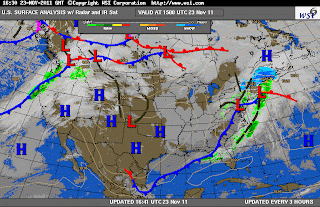
As is typical for late November, strong disturbances called extratropical cyclones frequently pass through our region. On November 22-23, periods of moderate rain combined with dense fog, followed by unseasonably mild temperatures and then a period of brisk winds as skies cleared. This sequence of weather describes the classic passage of a wave cyclone through the Baltimore region. Thirty of more of these cyclones traverse our region in the course of a typical year, although most are not especially intense.
The sequence of three surface weather charts below (courtesy of Intellicast) shows a warm front to the south of Baltimore on the evening of November 22 (red scalloped line). An extensive canopy of moderately heavy rain had overspread the region, in advance of the front, during the daytime. Dense patches of fog developed during the evening as the warm front approached from the south. This type of frontal fog is a common feature along warm fronts.
The warm front moved north through Baltimore after midnight, and quite paradoxically, temperatures began to rise into the lower 60's after midnight! This occurred as winds turned from the south and ushered in a warm air mass from the south, within the cyclone's warm sector. A band of heavy showers swept through Baltimore in the early morning hours, within the warm sector and ahead of the cold front.
Then, around Noon on November 23, the cold front pushed through from the west. This marked the arrival of a dry air mass, clearing skies, and strong winds. Paradoxically again, even with the early afternoon Sun, temperatures rapidly fell through mid-afternoon as a cold Canadian air mass arrived from the west and north.
The meteogram below (from Unisys) shows an atypical flip-flop between nightly minimum and daily maximum temperatures. This meteogram, from Dulles airport, shows temperature (green trace, upper panel) on November 22 and part of the 23rd. Note the steadily warming temperatures after midnight (05 UTC); the warmest temperature on November 23 actually came during the morning (61 F at 9 AM). The rapid drop in temperature through the afternoon (down to 51 F at 1 pm) followed the cold front. Wave cyclones, with their strongly contrasting temperature fields, frequently modulate the expected diurnal cycle of afternoon high temperature and nighttime low temperature.
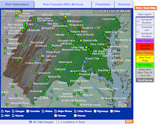
Prolonged moderate rainfall across central Maryland on Nov 22-Nov 23 lead to 2"-3" of accumulated rain and moderate flooding of the Monocacy River near Frederick, MD (below):
The other weather hazard of note was strong wind behind the cold front, particularly at the high elevations west and south of Baltimore. At the area airports (DCA, BWI, IAD) winds gusted to nearly 40 mph as the cold front swept through the region. These high winds were the result of a strong pressure gradient (pressure surge) behind the cold front (isobars are shown as solid black lines):
The NWS issued a Wind Advisory for counties immediately west of Baltimore, and a High Wind Warning for counties in the mountains of central Virginia:
Since friction reduces wind speed at Earth's surface, the high elevations of the Appalachians (3000'-4000') frequently experience stronger winds when the pressure gradient is intense. A High Wind Warning is issued when gusts are expected to exceed 50 mph. In the NWS maximum gust forecast for the afternoon, windy ridge tops show up quite dramatically. Also note the high wind gusts (nearly 50 mph) predicted for the middle of the Chesapeake Bay - a location where the wind accelerates across the extensive, flat water surface.


No comments:
Post a Comment