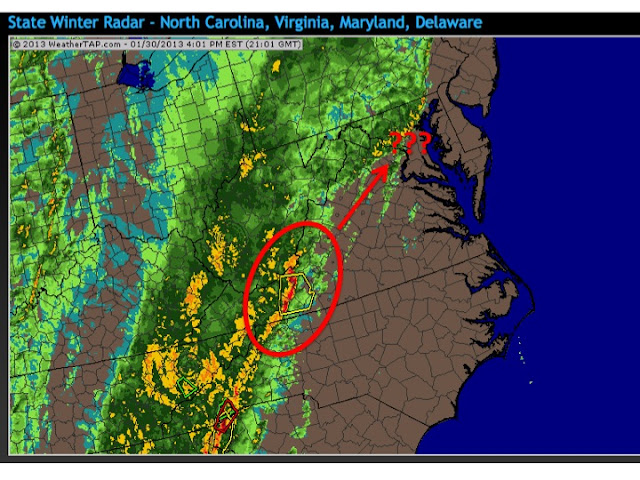
Here is the 4 pm radar snapshot, showing an extensive band of showers (with some embedded heavy cells) pushing our way from the west, ahead of a strong cold front:
I've circled the region over southwest Virginia. This is the nearest band of thunderstorms, producing local warnings for high wind. While this is over 200 miles to our southwest, there is some concern that this line could develop further north and east, heading toward our metro region during the evening. However, because of the extensive cloud cover all day, our region has not experienced intense solar heating, and thus there is very little instability in the atmosphere, to sustain a strong line of thunderstorms. My thinking is that the Baltimore area may be a bit too far north to get in on this action; the threat may be more for NOVA and Central Virginia.
The high-resolution computer forecast models continue to suggest that a band of moderate to strong rain showers will move through between 9-11 PM this evening, and these could create some locally strong wind gusts. The band is not expected to generate any lightning or thunder.
Also this evening, the strongest part of the the storm's pressure gradient will move across our region. This could bring higher sustained winds from the south, with gusts approaching 45 mph. Because of this, NWS Sterling has placed our region under a Wind Advisory. The winds covered under the advisory are widespread winds, generated by the larger region of low pressure, and NOT due to localized high gusts in showers or thunderstorms. This distinction is probably confusing. Here is the predicted range of wind gusts, at 10 PM tonite, the time widespread winds are expected to be their strongest:
The predictions are for gusts in the 40 mph range for D.C.-Baltimore, and in the 45-50 mph range over the higher terrain (foothills) to the west and north of the metro regions.
Also, the NWS continues its Flash Flood Watch for the entire region, as bands of moderate to heavy rain continue to work through our area overnight.


No comments:
Post a Comment