1:30 PM UPDATE: Line of heavy showers with gusty winds will arrive by 4 PM today. This initial line is well in advance of the main cold front; an additional band of heavy showers, with wind gusts, will sweep through through between 9 PM - Midnight. Thus far, the Storm Prediction Center has not forseen the need to issue severe thunderstorm or tornado watches for our region.
This is a very unusual weather situation for the Mid Atlantic in the dead of winter - an approaching squall line with temperatures soaring toward the 70 F mark. If this were late April or May, it would seem much more like normal.
The culprit is a large, extratropical cyclone (The Weather Channel has named it Winter Storm Magnus). As I discussed in earlier blogs, it's another storm with a "split personality": Heavy snow on its chilly, northwestern side, and severe thunderstorms on its warm and humid southeastern side. You can see the wide variety of weather this system is generating on the morning analysis chart below:
The blue swath over Wisconsin and Iowa is heavy snow. The dark green swath through the Ohio and Tennessee Valleys is a band of heavy showers and severe thunderstorms. The squall line has developed along a cold front approaching from the west. There is a warm front draped over Baltimore. To the south of this warm front, over Virginia and the Carolinas, lies the storm system's warm sector. The warm sector is where a warm and humid air mass streams northward from the subtropics. The advancing squall line is feeding on this air mass, and as it sweeps through the warm sector, it will continue to generate very heavy rain.
Regionally, here is the morning radar, which shows a squall line - a fast-moving, narrow band of heavy storms (red colors) - crossing the Appalachians from the west:
That band of storms is expected to sweep through our region this evening, after the end of rush hour. Thus far, there is no lightning, so this is technically not a line of thunderstorms - but the squall line is producing heavy downpours and gusty winds. The Storm Prediction Center is monitoring our region for possible issuance of severe thunderstorm watches. Additionally, a tornado watch is not out of the question - not so much from the squall line, but from any strong storms that develop along the warm front over Baltimore. Low-level winds often shift direction along a warm front, and this veering can create the spin that leads to rotating thunderstorms (supercells) and tornadoes.
While the wind setup is very intense for severe thunderstorms, the limiting factor may be the air mass sitting over central MD - which is somewhat cool and stable compared to regions further south and west. Thick, persistent cloud cover has kept the Sun from warming the surface and destabilizing the atmosphere.
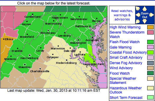
This will be a busy day and night for the NWS at Sterling, VA. Below is the latest set of watches and advisories for our region:
These include:
(1) Severe Thunderstorm Watch for the western slopes of the Appalachians;
(2) High Wind Warning for the western slopes of the Appalachians;
(3) Wind Advisory along the spine of the Blue Ridge;
(4) Flash Flood Watch for Central Maryland and the Appalachians
Flash flooding is a concern because 1"-2" of rain may fall in a very short time as the intense squall line, feeding on a humid air mass, sweeps through. High winds are a concern because the pressure gradient around this storm system is very compact - leading to widespread strong, sustained winds and high gusts. The winds are blowing at 60-70 mph from the south just a few thousand feet above the surface. Ridge tops that project up into this layer are therefore subject to experiencing many hours of high winds.
I will update this blog again in the afternoon, between 3-4 pm.


No comments:
Post a Comment