After an arctic front passage, the Great Lakes region often "clears up stormy", which refers to the development of Lake Effect snow showers. Very cold air and high winds moving over much warmer lake water (as long as the lake surface remains unfrozen) causes warming and moistening of the air layer just above the lakes. This destabilizes the air mass and causes it to convect (overturn), leading to showers of snow along and downwind of the lee shores.
Typically, these lake effect bands - which are quite narrow but can extend over 100 miles downwind - fizzle by the time they approach the Mason Dixon Line. But this afternoon, the arctic air mass is unstable enough...the wind trajectory is just right...and an upper air disturbance is helping to sustain uplift of air...allowing lake effect snow squalls to extend all the way into central MD and the Baltimore metro region. The skies are very scenic, with whitish streaks of snow falling from beneath deep cumulus clouds. Although the air beneath the cloud bases is very dry, some of these flakes are surviving to the surface. No one should receive any more than a dusting from these snow showers. Here is how the situation looks on weather radar - presenting as a very unique signature:
So enjoy a little taste of Lake Effect snow this afternoon!
Sunday, February 17, 2013
Tuesday, February 12, 2013
Feb 12, 2013: Nuisance Snow Event Wednesday Night
An area of low pressure beginning to form along the Gulf Coast, today, will intensity and track northeast tomorrow (Wednesday), passing south of Baltimore Wednesday night. This afternoon's weather map shows the low organizing a sizeable shield of precipitation across the southern Plains and southeast U.S.:
The forecast centers on two main questions: (1) How far to our south will the heaviest precipitation track; and (2) what form will the precipitation take? The latest model runs suggest we will pick up between 1/4"-1/2" precipitation:
The form of the precipitation - liquid vs. solid - depends on the thermal profile in the atmosphere's lowest 5,000 feet. Most scenarios suggest enough warm air initially present to start as rain, but with sub-freezing air pulled in on the backside of the system, the rain changes to snow. Assuming an 8:1 to 10:1 snow:liquid equivalent, we're talking 1"-2" in general. The rain-soaked ground will probably melt much of this on contact. If roads are adequately pre-treated, and treated during the event, they may remain wet or lightly slushed. So this event should mainly be a light, grass-surface snowfall. The system is not very intense, and it moves through our region briskly - both factors that will also limit accumulation.
Here is the official NWS snow accumulation forecast:
The snow amounts are higher to the north and west of the metro, for two reasons: (1) these regions will remain in the subfreezing air for a longer time; and (2) the air will be sub-freezing at higher elevations in the mountains. A shift in the forecast track can change this pattern, and if a small-scale snowband sets up - as some models are suggesting - snow amounts may be locally higher by several inches (often these bands are not well forecast).
The forecast centers on two main questions: (1) How far to our south will the heaviest precipitation track; and (2) what form will the precipitation take? The latest model runs suggest we will pick up between 1/4"-1/2" precipitation:
![]() |
| Forecast map, 1 AM Thursday, Feb 14 (Unisys Corp) |
Here is the official NWS snow accumulation forecast:
Thursday, February 7, 2013
Feb 7, 2013: Light Wintry Mix Early Friday AM; Monster Snowstorm To Our North
First, the local weather picture. For all the reasons given in my blog yesterday, a minor precipitation event is on tap for our region, Friday morning. A light wintry mix of sleet and freezing rain is possible very early Friday AM, starting before the morning rush. Temps warm through mid-morning (after 7 AM), changing precipitation to light rain. Here is the latest NWS forecast which reflects trace amounts of ice...bearing in mind, of course, that just a mere trace of black ice can cause a very significant rush hour impact:
Again, like last Saturday evening's dusting of snow, when traffic was heavy, just trace amounts of wintery precip can create all manor of havoc to traffic and pedestrian traffic in this region. Hopefully road crews will pre-treat before the morning rush. It's all timing, timing, timing...
The second major story is the development of a powerful Nor'easter off the Carolina Coast tomorrow night. This is the same storm that will bring us light precipitation tomorrow. As it moves offshore, then northeast off the coast (passing by the Delmarva shore) it will literally "bomb out" off the New England coast...bringing a bona fide blizzard to coastal New England... with up to 2 feet of snow and winds gusting in the 50-60 mph range. Not good for travel, nor for keeping the lights and heat on. It will be a close scrape on the very backside of the storm for us. Winds from the west-southwest will increase here Friday night into Saturday morning - possibly reaching Wind Advisory criteria at higher elevations to our west and northwest.
Here are the forecast maps showing this enormously powerful storm, which The Weather Channel is calling Winter Storm Nemo:
Again, like last Saturday evening's dusting of snow, when traffic was heavy, just trace amounts of wintery precip can create all manor of havoc to traffic and pedestrian traffic in this region. Hopefully road crews will pre-treat before the morning rush. It's all timing, timing, timing...
The second major story is the development of a powerful Nor'easter off the Carolina Coast tomorrow night. This is the same storm that will bring us light precipitation tomorrow. As it moves offshore, then northeast off the coast (passing by the Delmarva shore) it will literally "bomb out" off the New England coast...bringing a bona fide blizzard to coastal New England... with up to 2 feet of snow and winds gusting in the 50-60 mph range. Not good for travel, nor for keeping the lights and heat on. It will be a close scrape on the very backside of the storm for us. Winds from the west-southwest will increase here Friday night into Saturday morning - possibly reaching Wind Advisory criteria at higher elevations to our west and northwest.
Here are the forecast maps showing this enormously powerful storm, which The Weather Channel is calling Winter Storm Nemo:
![]() |
| Forecast map, Friday 7 AM, showing coastal low developing off Hatteras. We pick up light precipitation on the northwest side of the storm, as it slides out to sea. |
Wednesday, February 6, 2013
Feb 6, 2013: Light Icing, Then Rain, For Thursday Morning Rush
Winter continues with a succession of mainly weak areas of low pressure, containing limited moisture, in frozen form.
This has been our pattern for a couple weeks, because the jet stream at 30,000 feet is racing across the U.S. in a largely west-to-east configuration. When the jet stream flow in straight configuration, without significant meanders or bends, storm systems at the surface remain weak and fast-moving.
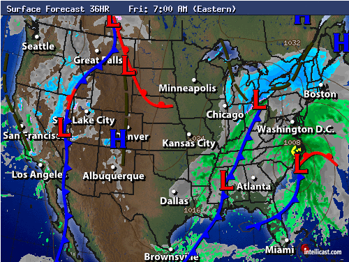
There are a few elements expected to come together Thursday morning, bringing the threat of a light wintry mix. These are shown in the forecast map below:
First is a blast of chilly, sub-freezing air from the northeast, as strong high pressure (the 1038 mb anticyclone sitting over Ontario, above) circulates cold air southward on clockwise winds. The cold, dense air hangs near the surface and piles up against the Appalachians. As the dome of chilly air builds over the Piedmont and metro areas, precipitation (forming as rain 5,000 feet above the surface) falling through the sub-freezing air layer will freeze into sleet (ice grains) or freezing rain (glaze ice - freezing on contact with the surface). The dome of cold, terrain-trapped air is called the cold wedge or cold air damming.
The source of moisture aloft is the second element shown above - a developing coastal low pressure system over the southeast U.S. The system will slide toward the northeast on Thursday morning, to a location off Cape Hatteras.
Now, let's advance the forecast map by 12 hours:
The coastal low has drawn closer to us, overspreading limited moisture. Light precipitation falls as a wintry mix. However, as the day progresses, two things happen: (1) the strong anticyclone supplying cold air retreats to the northeast; and (2) the coastal low pulls in milder air off the Atlantic, warming surface temperatures above freezing. These two changes erode the cold wedge, and precipitation changes to rain. Precipitation amounts are expected to be light, since the coastal low stays largely to our south and east of our region.
This has been our pattern for a couple weeks, because the jet stream at 30,000 feet is racing across the U.S. in a largely west-to-east configuration. When the jet stream flow in straight configuration, without significant meanders or bends, storm systems at the surface remain weak and fast-moving.
There are a few elements expected to come together Thursday morning, bringing the threat of a light wintry mix. These are shown in the forecast map below:
![]() |
| Surface forecast chart, Wednesday evening. |
The source of moisture aloft is the second element shown above - a developing coastal low pressure system over the southeast U.S. The system will slide toward the northeast on Thursday morning, to a location off Cape Hatteras.
Now, let's advance the forecast map by 12 hours:
![]() |
| Surface forecast chart, Thursday morning. |
Monday, February 4, 2013
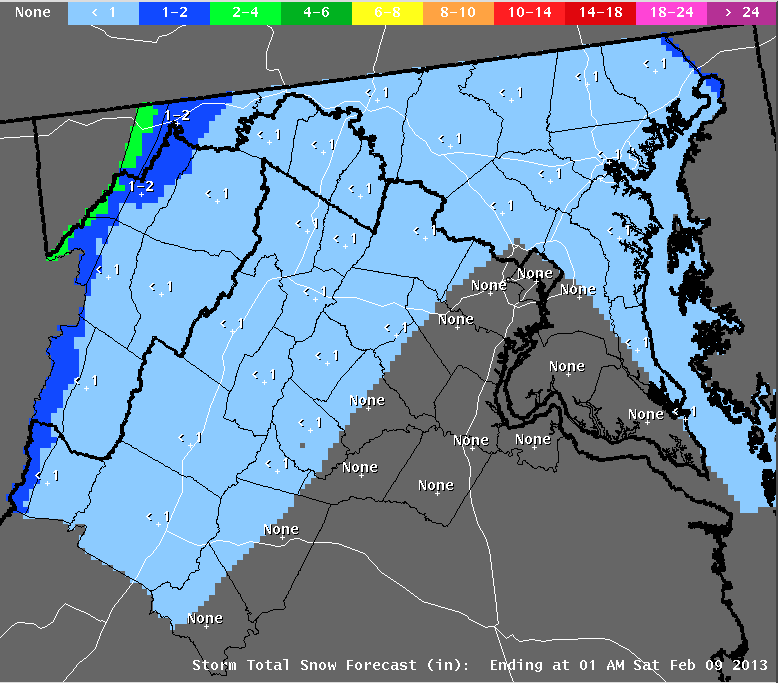
Feb 4, 2013: Quick Dusting To Light Accumulation Tonight
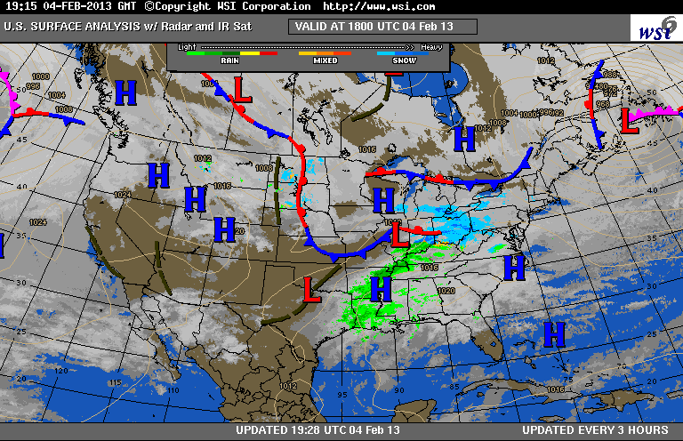
Once again, another Arctic Clipper - a weak, fast-moving, moisture-starved area of low pressure - will approach from the Ohio Valley, crossing our region over night.
You can see the approaching low pressure system below, over Illinois-Indiana, spreading a region of light snow (blue colors) our way:
The regional-scale (high resolution) forecast models suggest that more of the snow will fall on the western slopes of the Appalachians (this type of event is called Upslope Snow). Air forced to ascend the 3,000-4,000 ft slopes, on a westerly wind, cools, and water vapor freezes out as snow. When the air comes back down, crossing the eastern slopes, the air warms and dries. Thus in the urban corridor (Baltimore-Washington) we often see greatly reduced precipitation (and sometimes, no precipitation at all) - in these situations, we experience a "snow shadow" effect.
You can see the upwind, upslope region of enhanced snow (green) and the downwind snow shadow in the tonight's regional forecast model graphic:
The NWS is forecasting 1"-2" across Baltimore. The event will be over by the morning rush, but side streets will likely be untreated. Note the high amounts being forecasted just west of the Appalachian Divide:
You can see the approaching low pressure system below, over Illinois-Indiana, spreading a region of light snow (blue colors) our way:
The regional-scale (high resolution) forecast models suggest that more of the snow will fall on the western slopes of the Appalachians (this type of event is called Upslope Snow). Air forced to ascend the 3,000-4,000 ft slopes, on a westerly wind, cools, and water vapor freezes out as snow. When the air comes back down, crossing the eastern slopes, the air warms and dries. Thus in the urban corridor (Baltimore-Washington) we often see greatly reduced precipitation (and sometimes, no precipitation at all) - in these situations, we experience a "snow shadow" effect.
You can see the upwind, upslope region of enhanced snow (green) and the downwind snow shadow in the tonight's regional forecast model graphic:
The NWS is forecasting 1"-2" across Baltimore. The event will be over by the morning rush, but side streets will likely be untreated. Note the high amounts being forecasted just west of the Appalachian Divide:
Wednesday, January 30, 2013
January 30, 2013: Tornado Watch until 2 AM; Line of Storms Will Hit Within 1-2 Hours
The Storm Prediction Center has issued a Tornado Watch valid until 2 AM for the Washington-Baltimore metro area (yellow shaded region below).
A new squall line is rapidly developing and approaching our region from the southwest - depicted on radar below:
Note how the squall line (red colors) is bowing outward through central Virginia. Bow echoes such as this can generate pockets of intense wind damage called downbursts. Regarding the tornado watch, the concern is not for strong, supercell-generated tornadoes, but rather isolated, weak tornadoes that often develop with these bowing line segments. Any small tornado that forms may be difficult to detect by weather radar, and they are often invisible during dark and/or when enshrouded by heavy rain.
Oddly, there is unlikely to be any lightning and thunder associated with this line of storms.
The likely time that this squall line will pass through our region is between 7:30-9 PM tonight.
A Flash Flood Warning is in place for counties to the north and west of DC-Baltimore. Several inches of rain are possible from echo training - when more than one storm cell passes repeatedly over the same location.
A new squall line is rapidly developing and approaching our region from the southwest - depicted on radar below:
Note how the squall line (red colors) is bowing outward through central Virginia. Bow echoes such as this can generate pockets of intense wind damage called downbursts. Regarding the tornado watch, the concern is not for strong, supercell-generated tornadoes, but rather isolated, weak tornadoes that often develop with these bowing line segments. Any small tornado that forms may be difficult to detect by weather radar, and they are often invisible during dark and/or when enshrouded by heavy rain.
Oddly, there is unlikely to be any lightning and thunder associated with this line of storms.
The likely time that this squall line will pass through our region is between 7:30-9 PM tonight.
A Flash Flood Warning is in place for counties to the north and west of DC-Baltimore. Several inches of rain are possible from echo training - when more than one storm cell passes repeatedly over the same location.
January 30, 2013: Rainy, Windy Night On Tap
I'm continuing to monitor Winter Storm Magnus and its transit across the Mid Atlantic. All day we have been grappling with the threat of severe thunderstorms and heavy rain.
Thus far, no severe weather in Central Maryland. A band of heavy showers with gusty winds pushed through around 3 pm today. There was no lightning activity. Aside from the showers, winds have been gusting from the south at 25-30 mph. Moderate rain will continue to fall as evening approaches.
Here is the 4 pm radar snapshot, showing an extensive band of showers (with some embedded heavy cells) pushing our way from the west, ahead of a strong cold front:
I've circled the region over southwest Virginia. This is the nearest band of thunderstorms, producing local warnings for high wind. While this is over 200 miles to our southwest, there is some concern that this line could develop further north and east, heading toward our metro region during the evening. However, because of the extensive cloud cover all day, our region has not experienced intense solar heating, and thus there is very little instability in the atmosphere, to sustain a strong line of thunderstorms. My thinking is that the Baltimore area may be a bit too far north to get in on this action; the threat may be more for NOVA and Central Virginia.
The high-resolution computer forecast models continue to suggest that a band of moderate to strong rain showers will move through between 9-11 PM this evening, and these could create some locally strong wind gusts. The band is not expected to generate any lightning or thunder.
Also this evening, the strongest part of the the storm's pressure gradient will move across our region. This could bring higher sustained winds from the south, with gusts approaching 45 mph. Because of this, NWS Sterling has placed our region under a Wind Advisory. The winds covered under the advisory are widespread winds, generated by the larger region of low pressure, and NOT due to localized high gusts in showers or thunderstorms. This distinction is probably confusing. Here is the predicted range of wind gusts, at 10 PM tonite, the time widespread winds are expected to be their strongest:
The predictions are for gusts in the 40 mph range for D.C.-Baltimore, and in the 45-50 mph range over the higher terrain (foothills) to the west and north of the metro regions.
Also, the NWS continues its Flash Flood Watch for the entire region, as bands of moderate to heavy rain continue to work through our area overnight.
Here is the 4 pm radar snapshot, showing an extensive band of showers (with some embedded heavy cells) pushing our way from the west, ahead of a strong cold front:
I've circled the region over southwest Virginia. This is the nearest band of thunderstorms, producing local warnings for high wind. While this is over 200 miles to our southwest, there is some concern that this line could develop further north and east, heading toward our metro region during the evening. However, because of the extensive cloud cover all day, our region has not experienced intense solar heating, and thus there is very little instability in the atmosphere, to sustain a strong line of thunderstorms. My thinking is that the Baltimore area may be a bit too far north to get in on this action; the threat may be more for NOVA and Central Virginia.
The high-resolution computer forecast models continue to suggest that a band of moderate to strong rain showers will move through between 9-11 PM this evening, and these could create some locally strong wind gusts. The band is not expected to generate any lightning or thunder.
Also this evening, the strongest part of the the storm's pressure gradient will move across our region. This could bring higher sustained winds from the south, with gusts approaching 45 mph. Because of this, NWS Sterling has placed our region under a Wind Advisory. The winds covered under the advisory are widespread winds, generated by the larger region of low pressure, and NOT due to localized high gusts in showers or thunderstorms. This distinction is probably confusing. Here is the predicted range of wind gusts, at 10 PM tonite, the time widespread winds are expected to be their strongest:
The predictions are for gusts in the 40 mph range for D.C.-Baltimore, and in the 45-50 mph range over the higher terrain (foothills) to the west and north of the metro regions.
Also, the NWS continues its Flash Flood Watch for the entire region, as bands of moderate to heavy rain continue to work through our area overnight.
Subscribe to:
Posts (Atom)