The NWS has issued a Winter Weather Advisory for the western D.C. and Baltimore suburbs, effective tonight through tomorrow late morning, for slippery travel:

The Metro regions are barely on the edge of this advisory. In Central Maryland, the region of more significant impact is actually upper Montgomery and Howard Counties, where elevations are higher.
Here is the NWS accumulation map:
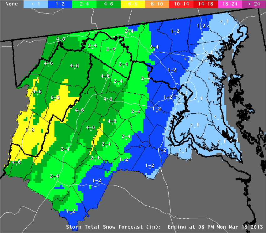
Like the last winter storm, this one is expected to be strongly elevation-dependent, with heaviest snow tied to colder air at the mountain tops. The Metro region is far from the expected snow accumulation bulls eye.
What's causing this wintery scenario over the Metro region? A weak area of low pressure approaching from the Tennessee Valley will pull in Atlantic moisture and create uplift of air. A classic pattern of Appalachian Cold Air Damming will supply marginally cold air over the low elevations. The damming is a subfreezing layer of air just a few thousand feet thick, wedged up against the eastern slopes of the Appalachians. The cold air is being pumped southward by high pressure over eastern Canada. The forecast map below shows the interaction of these elements:

We will have an air layer cold enough for snow and/or sleet over the Metro region, with Atlantic moisture overrunning the cold dome. As the high pressure moves eastward through the day on Monday, the wind direction will shift from a northerly to an easterly flow, bringing in warmer air off the mild Atlantic. This changes frozen precipitation to rain sometime Monday morning. Plain rain will persist through Monday night.
What could go wrong with this forecast? (1) The warmup will be delayed, leading to a longer period of frozen precipitation through the day Monday. Whenever we deal with cold air damming scenarios, this is always a possibility. The cold, dense air is hard to "scour out" and the prediction models often make the transition to warmer air too quickly. (2) The primary low to our west will transfer its energy to a coastal low, which then tracks up the New England coastline (dumping heavy snow on interior New England). The details of how the transfer will play out can impact available moisture, timing and intensity of uplift, and the wind field - all of which confound the forecast of multiple wintry precipitation types across our region.
How about the potential for a major snow storm late next weekend? Several cards are still on the table, including (1) a source of deep, subfreezing air moving southeast out of Canada; and (2) formation of a coastal storm, somewhere along or off the Atlantic coast. The details of the storm's formation 7+ days out remain problematic. Last night's model runs (both the GFS and ECMWF) developed a major, slow-moving cyclone off Cape Hatteras, with a frigid air mass in place over Washington-Baltimore - meaning big time snow. However, the afternoon runs of these same models have shifted the region of cyclone formation further south and east, over open ocean, and create the storm later, starting Tuesday, March 26. If these latest model runs are true, the impact here is minimal, or none at all.
The two sets of graphics below illustrate the large difference between the earlier and later model runs (the ECMWF is shown, but the GFS had very similar trends):
 |
| Earlier ECMWF run: Major Baltimore Snow Storm (Weatherbell Analytics) |
 |
| Later ECMWF run: A Miss for Baltimore (Weatherbell Analytics) |
No comments:
Post a Comment