The coastal low, while intensifying this afternoon, is out to sea and is exiting our region. It was a very compact system with a heavy but relatively small precipitation shield - with the bulls eye of liquid water content centered right over us. Truly a Mid Atlantic-Only storm.
As of 3 pm, the precipitation shield is finally on the move, ejecting toward the ocean. The mesoscale prediction models predict that the back edge of solid precip will clear D.C.-Baltimore by 6 pm this evening.
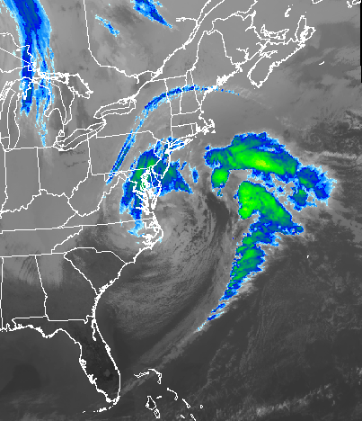
Here are some images of the storm, from different vantage points, at 3 PM. The first is the weather radar, which indicates that most of the precipitation has turned to light rain across the region:
 |
| Weaathertap |
Next up is the false-color infrared image, which gives information about cloud top temperature and height. The storm does not look nearly as well-organized in this presentation, but the swirl of low-level cloud about the storm's center of circulation is evident:
 |
| Weathertap |
 |
| Weathertap |

The general gradient in snow from east to west was well-predicted for this storm. The nature of the snow - heavy and wet - was also a good prediction. Here are some surprises or "curve balls" this storm threw into what proved to be a very challenging forecast:
1) Timing. The storm got ahead of the forecast by about 6 hours. Pure snow started falling area-wide by midnight, whereas most forecasts held off the arrival of all snow until daylight or mid- morning. Likewise, as the bulk of the precip will depart the region by 6 PM, this is sooner than called for yesterday;
2) Type of Precipitation. In many locations, light snow and rain were mixed together through much of the day. This cut down the snow accumulation predictions compared to last night, especially for the D.C. - Baltimore corridor;
3) Melting Through The Day. Temperatures remained several degrees above freezing, and even rose slightly during the day at some locations. Early, wet snow that started to stick on trees melted through the day. That, and the gusty winds, allowed the trees to shed their burden, sparing us from widespread power outages. Anticipation of power outages was perhaps the most dreaded aspect of this storm;
4) Stronger Wind Gusts Than Forecast: Last night, peak gusts were predicted to approach 35 mph, when in fact several locations were reporting gusts to nearly 50 mph early this afternoon - the province of Wind Advisory Criteria.
5) The Enormity of the Snow Accumulation Gradient: This is about as extreme as I've seen in the Mid Atlantic. 2" along I-95, vs. 20" along I-81 - a factor of ten difference. By all aspects, what defined the heavy snow region was altitude dependance. Here is a preliminary set of observed totals:

This will be the final post on this storm event.
No comments:
Post a Comment